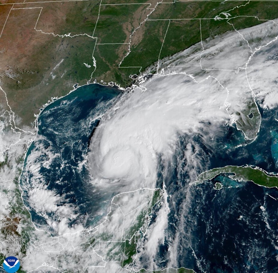
塞思·博伦斯坦报道:规模异常庞大的厄尔尼诺现象带来的强风,与墨西哥湾中温暖得足以催生风暴的海水,正在争夺着飓风“伊萨亚斯”的最终强度。从风暴的倾斜状态及其风眼形态便可看出哪一方占据上风。
SETH BORENSTEIN A supersized El Niño’s decapitating winds and the Gulf of Mexico’s toasty, storm-fueling waters are battling over the future strength of Hurricane Isaias . And the storm’s tilt and eye show who’s winning.
科罗拉多州立大学的飓风研究专家菲尔·克洛茨巴赫指出,整个大西洋飓风季都存在着“风切变与各类有利于风暴形成的条件之间的博弈”。
All Atlantic hurricane season there has been “this battle between shear and just the overall conducive conditions,” said Colorado State University hurricane researcher Phil Klotzbach.
厄尔尼诺现象——即太平洋部分海域出现的自然性暂时性增温现象,会引发全球天气异常——在这一过程中占据了主导地位。克洛茨巴赫称,其形成的风场模式几乎抑制了大西洋上任何微弱风暴的增强,却促使太平洋海面温度升至创纪录水平。
El Niño — the natural temporary warming of parts of the Pacific that warps weather worldwide — dominated. Its wind patterns smothered almost any wisp of a storm from strengthening in the Atlantic, while boosting what will soon be record high levels in the Pacific, Klotzbach said.
据克洛茨巴赫与奥尔巴尼大学的克里斯汀·科尔博西罗介绍,这种被称为“风切变”的现象会使风暴的顶部和中部发生偏移,导致风暴形态不对称,难以形成完整的环形风眼结构,而只有形成这种结构风暴才能真正增强威力。
It’s called wind shear and it pushes the tops and middle of storms around, making them lopsided and keeping them from making a complete circular eyewall, which is when storms can really power up, Klotzbach and University at Albany’s Kristen Corbosiero said.
不过,促使风暴迅速增强的其他条件也在发挥作用:温暖的海水与充足的水汽为风暴提供了充足“燃料”。目前墨西哥湾的海水温度比常年高出约2.7华氏度(1.5摄氏度)。非营利机构“气候中心”的副总裁、气候科学家克里斯蒂娜·达尔指出,由于燃烧煤炭、石油和天然气引发的气候变化,如今墨西哥湾出现86华氏度(30摄氏度)高温海水的可能性比以往高出100至500倍。该机构专门测算全球变暖对极端天气的影响程度。
The other ingredients for a storm to turbocharge a storm are pushing back. There is plenty of fuel in warm water and moisture. The Gulf of Mexico is about 2.7 degrees (1.5 degrees Celsius) warmer than normal. The 86 degree waters (30 degrees Celsius) are 100 to 500 times more likely to be that extra hot because of climate change from the burning of coal, oil and gas, said climate scientist Kristina Dahl, vice president of the nonprofit Climate Central, which calculates the boost global warming causes to extreme weather.
“不过到了某个临界点,无论海水有多热、水汽有多充足,只要风切变强度超过阈值,风切变就会占据上风,”克洛茨巴赫说道。
“But there’s a certain point where it’s like, I don’t care how hot the waters are and how much moisture you have, if shear gets to a certain point, the shear is gonna win,” Klotzbach said.
专家介绍,本周早些时候,一些可能发展成大风暴的雷暴雏形在中美洲上空形成了环形气流,但由于厄尔尼诺现象引发的强高空风将风暴顶部吹向一侧,这些雏形往往形态不对称,始终无法形成关键的环形风眼结构。
The thunderstorm seeds of something bigger earlier in the week grew from circular winds over Central America but often were lopsided and couldn’t quite form a crucial eyewall, all because of El Niño’s high-level strong winds that pushed a would-be storm’s top sideways, experts said.
科博西埃罗表示,随后出现了短短两天的天气缓和期,但这已经足够了。她指出,这种情况出现在墨西哥湾且发生在10月份也合乎常理,因为厄尔尼诺现象对墨西哥湾的影响要小于对大西洋其他地区的影响。此外,由于来自北方的风暴系统会促成适宜条件,10月份该地区也常常会出现风暴。
Then a window of moderation opened for just a couple of days, but it was enough, Corbosiero said. It makes sense it was in the Gulf of Mexico and in October, because El Niño has less of an effect in the Gulf than it does in the main Atlantic, she said. And storms often pop up in that region in October because of more northerly storm systems that help foster the right conditions.
虽然风切变程度并不算低,但仍处于中等水平,此时异常温暖的海水与大量水汽等条件便开始发挥作用。克洛茨巴赫称,伊萨亚斯在一天之内风速便从每小时40英里迅速提升至80英里(即每小时64公里增至129公里)。到周三晚些时候,它便成为自1914年以来同期形成的最晚首场大西洋飓风。
Wind shear wasn’t exactly low, but it was a moderate level, when other factors like unusually warm waters and heavy moisture can kick in. Isaias rapidly intensified from 40 mph to 80 mph (64 kph to 129 kph) in a day and by late Wednesday, Isaias became the latest-in-the-season first Atlantic hurricane to form since 1914, Klotzbach said.
“温暖的海水与充沛的水汽占了上风,”克洛茨巴赫说道。预计伊萨亚斯的风向会逐渐趋于稳定,并沿着直线路径强劲移动。
“The warm waters and high moisture won,” Klotzbach said. Isaias is likely losing its tilt and straightening and flying right and strong.
据克洛茨巴赫及美国国家飓风中心的预报,周五时该飓风的风速有望短暂达到每小时111英里(178公里),从而具备强飓风的特征。不过这种状态很可能只是暂时的。
For a few hours, the storm is forecast on Friday to flirt with 111 mph (178 kph) winds that could possibly give it major hurricane status, according to Klotzbach and the National Hurricane Center’s forecast. But it’ll likely be temporary.
克洛茨巴赫指出,在伊萨亚斯登陆之前——预计将于周五深夜或周六凌晨在密西西比州与阿拉巴马州海岸至佛罗里达狭长地带之间登陆——风切变强度将从目前每小时约20英里(32公里)的中等水平升至52英里(84公里)。届时飓风强度将开始减弱,这对沿岸居民而言是个好消息。
Before Isaias comes ashore — forecast for probably somewhere from the Mississippi and Alabama coast to the Florida Panhandle late Friday night or early Saturday — the wind shear will strengthen from moderate levels of around 20 mph (32 kph) to 52 mph (84 kph) and then Isaias will start to struggle, which is good news for coastal residents, Klotzbach said.
克洛茨巴赫称,伊萨亚斯登陆时很可能为强一级飓风或弱二级飓风,尚不至于成为强飓风,不过仍可能造成相当大的破坏。
It will probably come ashore as a strong Category 1 or weak Category 2 storm, but not a major storm, Klotzbach said. It can still do plenty of damage.
“一旦风暴登陆海岸,由于气候变化导致的海平面上升,风暴潮的深度和影响范围都会增大,”达尔说道。“在过去100年左右的时间里,这一地区的海平面上升了约6.5英寸,这一变化完全可归因于气候变化。”
“Once it gets to the coast, we know that the storm surge is going to be deeper and farther reaching because of sea level rise caused by climate change,” Dahl said. “So in this part of the world, there’s been about six and a half inches of sea level rise over the past 100 years or so that’s attributable directly to climate change.”
美国国家飓风中心称此次风暴潮“足以致命”。达尔指出,大气温度升高使得风暴能够携带更多水分并最终倾泻而下,从而加剧洪水灾害。飓风中心警告称,本周末东南部地区可能出现城市内涝、河流泛滥以及突发性洪水。
The National Hurricane Center is calling the surge “life-threatening.”A warmer atmosphere means storms hold and then dump more rain, worsening flooding, Dahl said. The hurricane center is warning about urban, river and flash flooding in the Southeast this weekend.
“目前虽然存在一些争议,但我认为最关键的一点是:气候变化是导致全球长期气温升高的根本原因,而厄尔尼诺现象不过是锦上添花罢了,”达尔说道。
“There’s a little bit of a battle here going on, but I think the really important thing to remember is that climate change is like this long-term big kahuna warming everywhere, and El Niño’s like a little icing on the cake,” Dahl said.