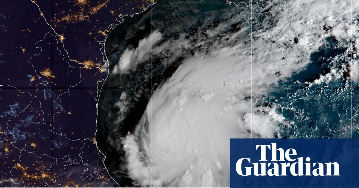
热带风暴“伊萨亚斯”于周三清晨在墨西哥东部海域的温暖水域形成。气象预报员称,该风暴预计会逐渐增强,成为本季大西洋飓风季的首个飓风,并于本周晚些时候袭击美国墨西哥湾沿岸地区。
Tropical Storm Isaias formed early on Wednesday in the warm waters off eastern Mexico and forecasters said it was expected to strengthen into the first hurricane of the belated Atlantic season before hitting the US Gulf coast later in the week.
“伊萨亚斯”是在夜间由热带低气压九号发展而来。据美国国家飓风中心(NHC)消息,目前该风暴位于墨西哥普罗格雷索以西约285英里(460公里)处,以及路易斯安那州密西西比河注入墨西哥湾处西南约580英里(935公里)处。周三上午,“伊萨亚斯”的最大持续风速为每小时40英里(65公里/小时),正以每小时8英里(13公里/小时)的速度向东偏东北方向移动。
Isaias succeeded Tropical Depression Nine as it strengthened overnight. It was located about 285 miles (460km) west of Progreso, Mexico, and about 580 miles (935km) south-west of where the Mississippi River spills into the Gulf of Mexico in Louisiana, according to the National Hurricane Center (NHC). The storm on Wednesday morning had maximum sustained winds of 40mph (65kph) and was moving east to north-east at 8mph (13kph).
自1905年10月8日以来,大西洋飓风季首次在如此晚的时节才出现首个飓风。美国国家飓风中心预测,该风暴将迅速增强,并在登陆前发展为强度较高的二级飓风。
The first hurricane of the Atlantic season has not formed this late since 8 October 1905. The NHC said the storm is expected to strengthen rapidly and become a strong category 2 hurricane before landfall.
目前尚不清楚“伊萨亚斯”具体会在美国墨西哥湾沿岸的何处登陆。根据飓风中心的初步预测,风暴中心可能会在路易斯安那州东部至佛罗里达州狭长地带西部之间的某处登陆。相关部门已敦促上述地区的居民做好应对风暴的准备。
It was not immediately known where the storm may make landfall on the US Gulf coast. The hurricane center’s initial projections said the center of Isaias could come onshore somewhere between eastern Louisiana and the western Florida Panhandle. People in those areas were urged to prepare for the storm .
位于佛罗里达州迈阿密的飓风中心提醒称:“墨西哥湾北部沿岸部分地区面临强风与风暴潮带来的风险正日益升高。从路易斯安那州到佛罗里达州狭长地带的居民应密切关注最新预报信息,并确保自己的飓风应对预案已准备妥当。”气象预报员同时指出,目前尚无法确定风暴何时转向东北方向以及其向海岸移动的速度。虽然风暴路径有可能使其于周六清晨在阿拉巴马州与佛罗里达州交界处登陆,但美国国家飓风中心重申,其具体路径仍存在不确定性。
“There is an increasing risk of dangerous wind and storm surge impacts along portions of the northern Gulf Coast,” the hurricane center, based in Miami, Florida said. “Residents from Louisiana to the Florida Panhandle should closely monitor the latest forecast updates and ensure they have their hurricane plan in place.”Forecasters added that there is “uncertainty in where the system makes the northeast turn and how fast it moves toward the coast”. The direction of the storm could see it make landfall where Alabama meets Florida early on Saturday, but the NHC reiterated that the exact path is uncertain.
此次风暴的来袭正值大西洋飓风季。由于厄尔尼诺现象异常强烈,该海域的风暴形成受到抑制,因此今年飓风活动异常稀少。相比之下,太平洋地区的风暴活动则高于平均水平。
The storm comes as the Atlantic hurricane season has been unusually quiet this year owing to a particularly strong El Niño, which disrupts storm formation over that ocean. Storm activity in the Pacific has been above average.
今年规模巨大的厄尔尼诺现象正在引发全球气候紊乱。从西欧到加利福尼亚,多地都打破了气温记录,出现极端高温天气。与此同时,曼谷正遭受严重洪灾。据预测,到2月份,这一气候现象还可能导致全球额外45万人死亡。本文由美联社提供报道。
This year’s huge El Niño is causing climate chaos around the world. Temperate records have already been broken, with extreme heat reported from western Europe to California. Meanwhile, Bangkok is suffering massive flooding and the weather phenomenon is projected to cause a further 450,000 deaths globally by February. The Associated Press contributed reporting.