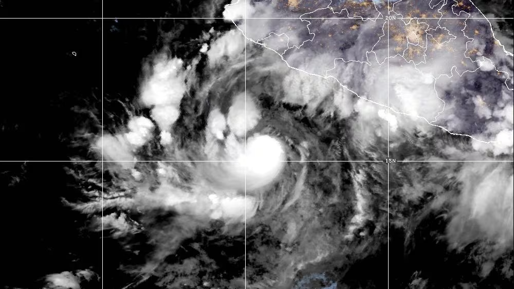
周五,飓风“西蒙”正朝墨西哥太平洋沿岸移动,预计其强度会显著增强。
Hurricane Simon was headed toward part of Mexico's Pacific coast on Friday and forecast to get much stronger.
美国气象部门已对该国中部及西南沿海部分地区发布了飓风警报,预计这些地区将在36小时内出现飓风级别的大风。
U.S. forecasters issued a hurricane warning for parts of the central and southwest coast, where hurricane-force winds were expected within 36 hours.
据迈阿密的美国国家飓风中心消息,周五清晨时“西蒙”的最大持续风速为每小时120公里,正以每小时7公里的速度向西北方向移动。
Simon had maximum sustained winds of 120 km/h early Friday and was moving northwest at seven km/h, the U.S. National Hurricane Center in Miami said.
作为一级飓风,“西蒙”预计将于周六清晨转向北方并靠近海岸线,随后迅速增强为四级飓风。
The Category 1 hurricane was forecast to turn to the north by early Saturday and approach the coast. Simon was expected to intensify rapidly and become a Category 4 storm before landfall.
按照萨菲尔-辛普森等级标准,四级飓风的最大持续风速介于每小时210至250公里之间。
Category 4 hurricanes on the Saffir-Simpson scale have maximum sustained winds of 210 to 250 km/h.
“西蒙”目前位于曼萨尼约以南约355公里、卡波科连特斯东南偏南约525公里的海域。周五晚些时候,当地沿海区域可能出现热带风暴天气。
Simon was centered about 355 kilometres south of Manzanillo and 525 kilometres south-southeast of Cabo Corrientes. Tropical storm conditions were possible along the coast later Friday.
该飓风还将带来大量降雨,极易引发洪水与泥石流;气象部门预测,墨西哥西南部降雨量可达20至38厘米,局部地区甚至可能超过63厘米。
Simon was expected to produce torrential rainfall that could cause flooding and mudslides. U.S. forecasters said 20 to 38 centimetres of rain could fall in southwestern Mexico, with isolated areas getting up to 63 centimetres.
另据消息,热带风暴“瑞秋”预计将于本周末登陆墨西哥西北部的下加利福尼亚州及美国南加州地区,目前其风速为每小时95公里,虽预计强度会有所减弱,但仍可能给上述区域带来强降雨。
Updates on Tropical Storm Rachel, Hurricane Isaias Farther north, Tropical Storm Rachel was expected to reach Baja California, northwestern Mexico and Southern California this weekend. It had 95 km/h winds and was forecast to weaken, though it may bring heavy rain to the area.
受强厄尔尼诺现象影响,今年太平洋海域的热带风暴活动频率高于往年。眼下已临近9月末,为何大西洋地区的飓风仍寥寥无几呢?事实上,这一气候现象通常会抑制大西洋上的风暴生成。
而原定于周五或周六登陆美国墨西哥湾沿岸的飓风“伊萨亚斯”,则是在大西洋飓风季进入第四个月后才形成的。
Tropical storm activity has been above average this season in the Pacific, due to the effects of a strong El Niño. It's almost the end of September. Where are all the hurricanes? The climate phenomenon typically depresses storm activity in the Atlantic Hurricane Isaias, which was expected to hit the U.S. Gulf Coast late Friday or Saturday, developed more than four months into the Atlantic hurricane season.