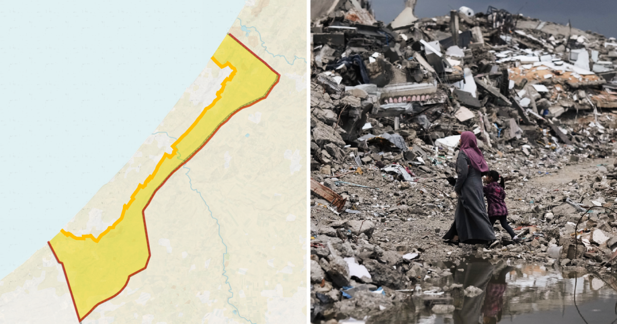
以色列扩大了其在加沙地带的军事占领,此举违反了美国斡旋达成的“停火”协议,迫使巴勒斯坦人只能挤在遭到以色列持续灭绝性战争摧毁、面积不断缩小的被围困领土上。
Israel has expanded its military occupation in the Gaza Strip in violation of a United States-brokered‘ceasefire’ forcing Palestinians into an ever-smaller share of the besieged territory, devastated by Israel’s ongoing genocidal war.
加沙近三分之二的土地目前处于以色列军事控制之下或面临通行限制。
Nearly two-thirds of Gaza is now under Israeli military control or subject to access restrictions.
最初的“黄线”是在美国总统唐纳德·特朗普旨在结束战争的20点计划下设立的,标志着以色列军队最初撤出的区域。他们本应逐步进一步撤军,但相反,他们夺取了更多领土。
The original ‘Yellow Line’, established under US President Donald Trump’s 20-point plan to end the war, marked the area to which Israeli forces initially withdrew. They were expected to make further withdrawals gradually, but instead, they have seized more territory.
周日,以色列军队将加沙城东南部舒贾亚(Shujayea)街区的黄色混凝土路障向西移动了数十米,迫使巴勒斯坦家庭逃离,并将该街区更多地区置于以色列的军事控制之下。
On Sunday, Israeli forces moved yellow concrete blocks dozens of metres west in Shujayea, a neighbourhood in southeastern Gaza City, forcing Palestinian families to flee and bringing more of the neighbourhood under Israeli military control.
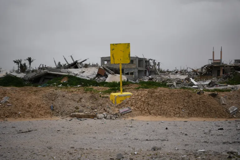
2026年1月22日,在加沙地带南部汗尤尼斯,可以看到一个划定“黄线”的黄色路障。自一年前“停火”开始以来,“黄线”一直将加沙地带的以色列控制区和巴勒斯坦人区域隔开 [阿卜杜勒·卡里姆·哈纳 / 美联社照片]半岛电视台记者易卜拉欣·哈利利(Ibrahim al-Khalili)在加沙城报道称:“这不仅仅关乎‘黄线’今天在哪里,还关乎它接下来会移到哪里。对于在过去三年中屡次流离失所的家庭来说,局势依然严峻,他们必须做出艰难的决定,思考自己究竟能去哪里。”
A yellow block demarcating the ‘Yellow Line’, which has separated the Gaza Strip’s Israeli-held and Palestinian zones since a ‘ceasefire’ began a year ago, is seen in Khan Younis in the southern Gaza Strip on January 22, 2026 [Abdel Kareem Hana/AP Photo]“It’s not simply about where the ‘Yellow Line’ is today but where it can move next,” Al Jazeera’s Ibrahim al-Khalili said, reporting from Gaza City. “For families who have been repeatedly displaced in the past three years, the situation remains dire, and they have to make the impossible decision of where they can go.”
自2023年10月7日哈马斯领导对以色列南部发动袭击、引发以色列战争以来,加沙210万人口中已有超过90%的人被迫流离失所。
More than 90 percent of Gaza’s 2.1 million population has been forcibly displaced by Israel’s war, launched on October 7, 2023, after Hamas-led attacks on southern Israel.
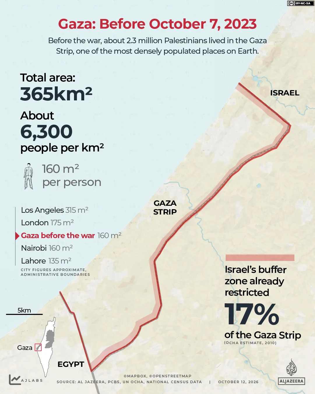
半岛电视台利用地图展示了自“停火”以来以色列夺取了多少加沙领土。战前的加沙战前,巴勒斯坦人分布在加沙地带,这是一片面积365平方公里(141平方英里)、长约41公里(25公里)、宽6至12公里(4至7英里)的领土。
Using maps, Al Jazeera shows how much of Gaza Israel has grabbed since the ‘ceasefire’. Gaza before the war Before the war, Palestinians were spread across the Gaza Strip, a 365sq km (141sq-mile) territory roughly 41km (25 miles) long and from 6km to 12km (4 to 7 miles) wide.
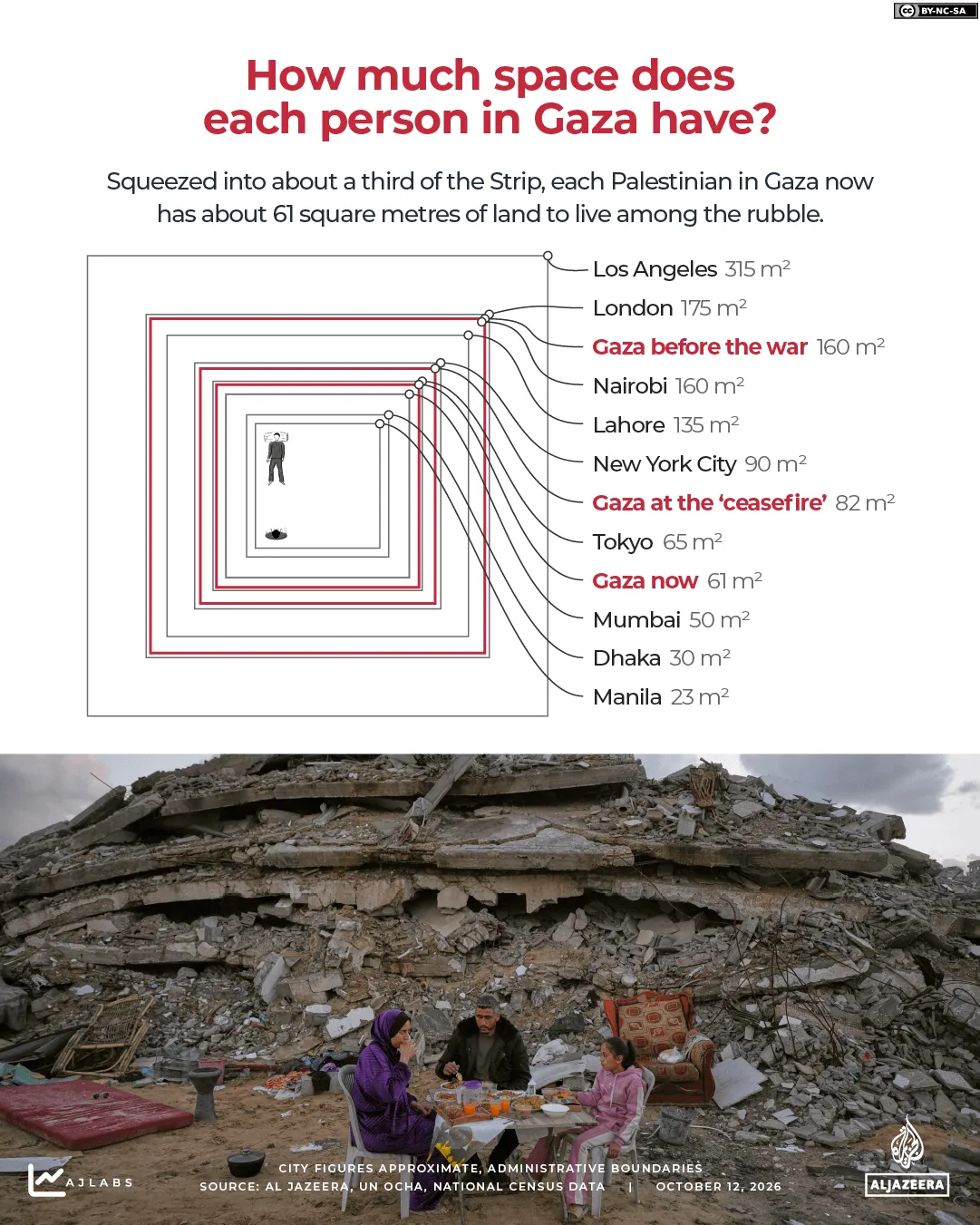
这使其成为地球上人口最稠密的地区之一,每平方公里约有6,000人,类似于内罗毕或伦敦。平均每个人拥有约160平方米(1,722平方英尺)的土地。
That made it one of the most densely populated places on Earth with about 6,000 people per square kilometre, similar to Nairobi or London. Each person had, on average, about 160sq metres (1,722sq ft) of land.
即便如此,加沙并非所有土地都可进入。以色列在与以色列的隔离栅栏沿线实施了缓冲区,接近该区域的巴勒斯坦人面临被枪击的危险。2010年,联合国人道主义事务协调厅(OCHA)估计,受限制区域占加沙土地的17%和农田的35%。
Even then, not all of Gaza’s land was accessible. Israel enforced a buffer zone along the fence with Israel, and Palestinians who approached it risked being shot. In 2010, the United Nations Office for the Coordination of Humanitarian Affairs (OCHA) estimated that the restricted area covered 17 percent of Gaza’s land and 35 percent of its farmland.
自2007年以来,加沙一直遭受以色列的陆地、空中和海上封锁。停火时的加沙根据“停火”第一阶段,以色列军队须在24小时内撤至“黄线”,随后开始为期72小时的移交被扣押在加沙的以色列人员的期限。特朗普首次在其“真相社交”(Truth Social)平台上发布了一张该线路的地图。
Gaza has been under an Israeli land, air and sea blockade since 2007. Gaza at the ‘ceasefire’Under the first phase of the “ceasefire”, Israeli forces were to withdraw to the “Yellow Line” within 24 hours, after which a 72-hour period began for the handover of Israeli captives held in Gaza. Trump first published a map of the line on his Truth Social platform.
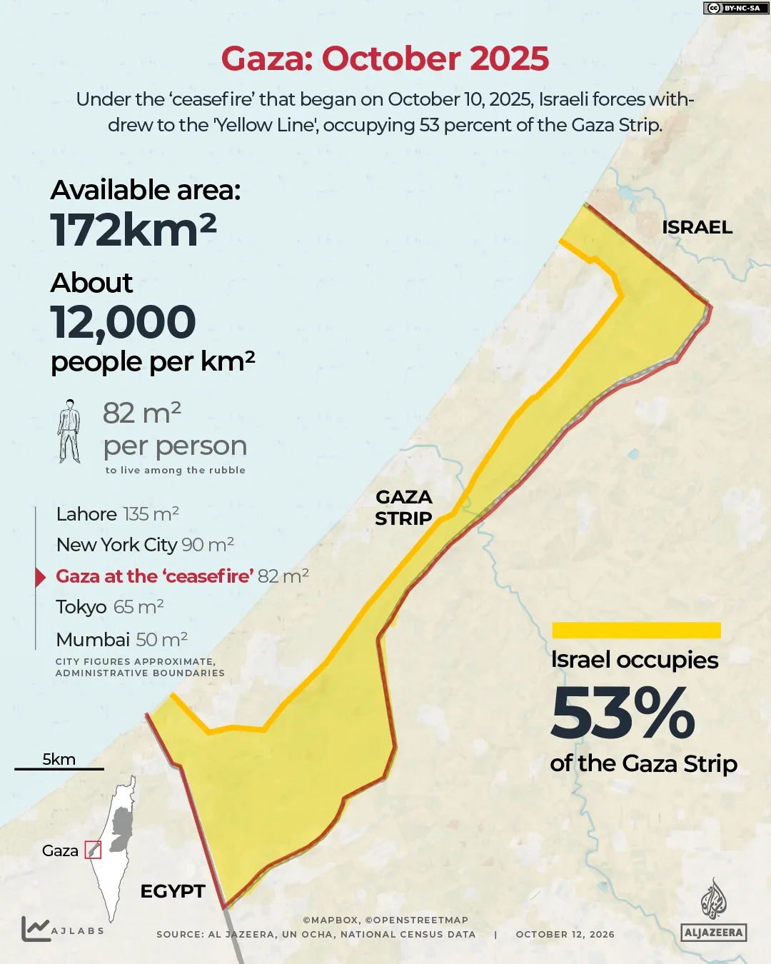
这条线使以色列控制了该地带53%的土地,主要是东部的农田和边境地区,并将巴勒斯坦人限制在其余47%的土地上,即约172平方公里(66平方英里)。
The line left Israel in control of 53 percent of the Strip, mostly farmland and border areas in the east, and confined Palestinians to the remaining 47 percent, about 172sq km (66sq miles).
截至2025年10月,长达两年的战争已导致6.7万多名巴勒斯坦人死亡,数万人离开该领土,使加沙人口减少至约210万。
By October 2025, two years of war had killed more than 67,000 Palestinians, and tens of thousands more had left the territory, reducing Gaza’s population to about 2.1 million.
根据“停火”协议,他们被挤压在加沙不到一半的领土上,人口密度翻了一番,达到每平方公里约12,000人,堪比纽约市。每个人仅剩下约82平方米(883平方英尺)的土地。今日的加沙“停火”之后,以色列军队多次将标志着“黄线”的黄色混凝土路障进一步向西移动,有时在夜间进行,从而扩大了他们控制的区域。卫星图像也记录了以色列军队控制区内持续进行的拆除行动。
Pushed into less than half of Gaza’s territory under the “ceasefire”, its density doubled to about 12,000 people per square kilometre, comparable to New York City. Each person was left with about 82sq metres (883sq ft). Gaza today Since the “ceasefire”, Israeli forces have repeatedly moved the yellow concrete blocks marking the “Yellow Line” farther west, sometimes overnight, expanding the areas under their control. Satellite imagery has also documented continued demolitions in areas held by Israeli forces.
研究组织“法医建筑”(Forensic Architecture)估计,截至12月,以色列控制了加沙58%的土地。3月,以色列军方向人道主义机构发送了一张新“橙线”的地图,“橙线”是“黄线”之外的一个限制区,在该区域内的人道主义行动必须与军方进行协调。
The research group Forensic Architecture estimated that Israel controlled 58 percent of Gaza by December. In March, the Israeli military sent aid agencies maps of a new “orange line”, a restricted zone beyond the “Yellow Line” where humanitarian movements must be coordinated with the army.
据联合国人道主义事务协调厅称,限制现在覆盖了加沙65%的土地。一名联合国官员6月在安理会上表示,以色列自己称其控制了大约70%的领土。
According to OCHA, restrictions now cover 65 percent of Gaza. Israel itself said it controls about 70 percent of the territory, a UN official told the Security Council in June.
这使得210万人挤在该地带大约35%的土地上,即约128平方公里(49平方英里)。自战前以来,人口密度几乎增加了两倍,达到每平方公里约16,000人,接近东京市中心。
That leaves 2.1 million people in about 35 percent of the Strip, roughly 128sq km (49sq miles). The population density has nearly tripled since before the war to about 16,000 people per square kilometre, close to central Tokyo.
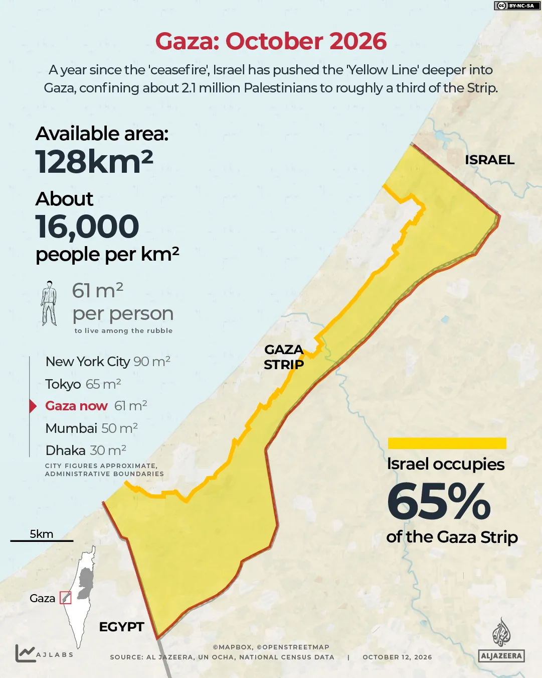
现在,每个人只有大约61平方米(657平方英尺)的土地用于一切用途:住所、道路、学校、医院和农田。
Each person now has about 61sq metres (657sq ft) of land for everything: shelter, roads, schools, hospitals and farmland.
与东京不同,加沙几乎没有剩余空间来容纳其人民。联合国卫星中心(UNOSAT)发现该地带82%的建筑受损或被毁。联合国粮食及农业组织表示,加沙仅有3%的耕地既完好又可进入。
Unlike Tokyo, Gaza has little space left to house its people. The UN Satellite Centre, UNOSAT, found 82 percent of structures in the Strip are damaged or destroyed. The UN Food and Agriculture Organization says only 3 percent of Gaza’s cropland is both undamaged and accessible.
联合国人道主义事务协调厅表示,加沙剩下的35%的土地“已经过度拥挤”,随着援助团伙试图在雨季来临之前重新安置家庭,通行限制是一个主要障碍。据联合国称,有95万多人生活在面临洪水风险的流离失所者营地中,其中大多数人住在帐篷和临时避难所里,如以下卫星图像所示。
OCHA says the remaining 35 percent of Gaza is “already overcrowded” and access restrictions are a key obstacle as aid groups try to relocate families before the rainy season. More than 950,000 people live in displacement sites at risk of flooding, according to the UN, most of them in tents and makeshift shelters, as seen in the satellite image below.
接近“黄线”可能是致命的。以色列将线外区域视为自由开火区,靠近该区域的巴勒斯坦人遭到了枪击。自宣布停火以来,加沙各地已有近1,500人丧生。
Approaching the ‘Yellow Line” can be deadly. Israel treats areas beyond it as a free-fire zone, and Palestinians who come near it have been shot. Nearly 1,500 people have been killed across Gaza since the ceasefire was announced.