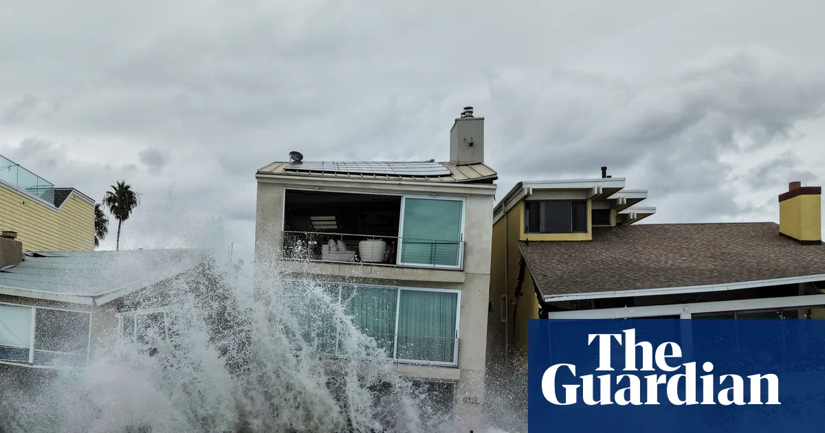
南加州沿海社区正在收拾周末极端天气留下的残局,洪水淹没城市街道,巨浪冲击海滨住宅。
Southern California coastal communities are picking up the pieces after a weekend of extreme weather brought flooding that overtook city streets and intense waves battered beachside homes.
热带风暴雷切尔的残余系统周末袭击了墨西哥的下加利福尼亚州,也影响了南加州和拉斯维加斯。虽然气象学家指出,雷切尔在接近加州时减弱为后热带气旋,但它仍留下了一路破坏。
The remnants of Tropical Storm Rachel hit Mexico’s Baja California over the weekend as well as southern California and Las Vegas. While meteorologists noted that Rachel weakened into a post-tropical cyclone as it approached California, it still left a trail of destruction.
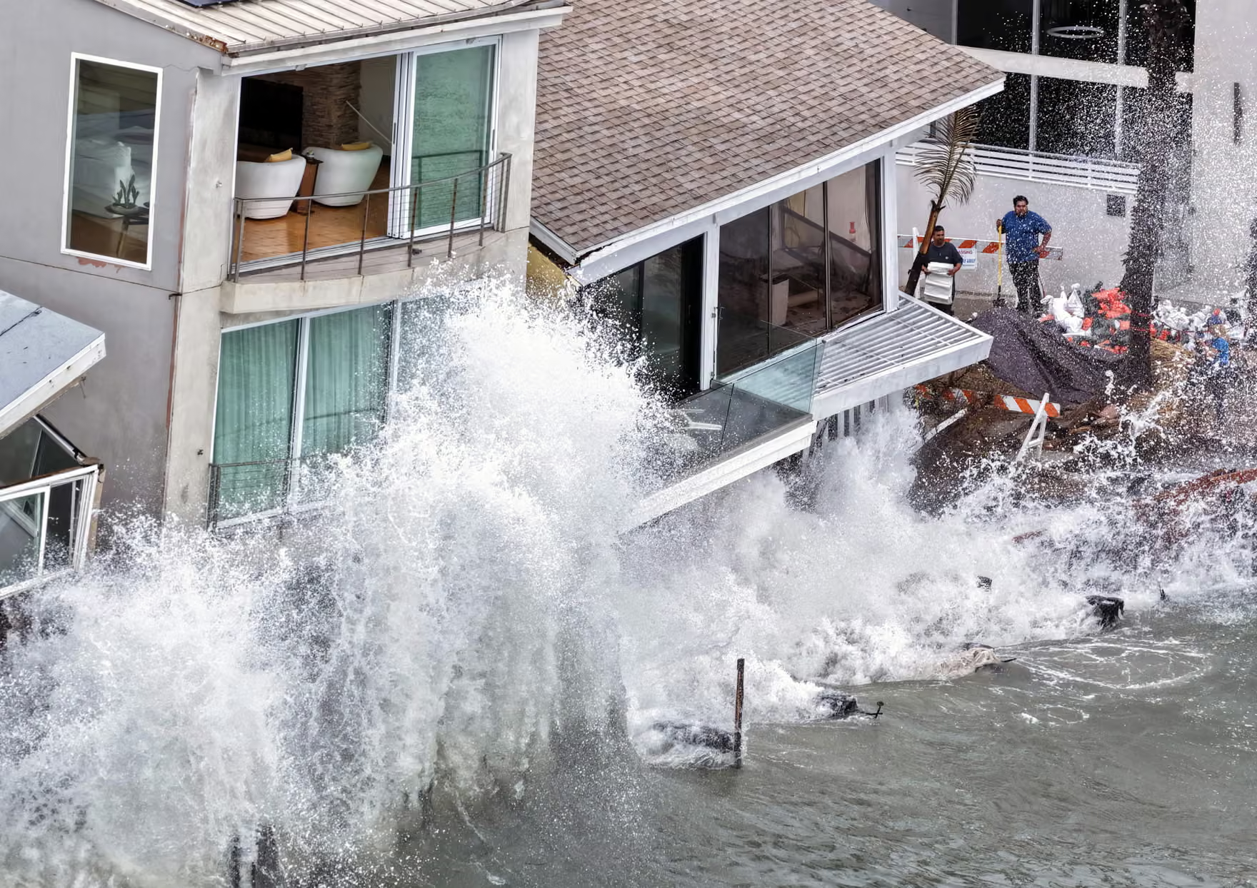
画面显示,巨浪冲击长滩住宅,毁坏了海滨步道,迫使居民逃离。房屋受损严重,部分房屋存在倒塌风险。
Footage showed massive waves crashing into Long Beach homes, destroying a boardwalk and forcing residents to flee. The damage to homes was significant, leaving some at risk of collapse.
长滩邮报报道称,至少有九处房屋被认定为不安全进入,这意味着流离失所的居民无法返回取回个人物品。据该媒体报道,这场风暴已使该市动用应急储备金超过100万美元。
At least nine have been deemed unsafe to enter, the Long Beach Post reported, meaning displaced residents cannot return to retrieve personal items. The storm has cost the city more than $1m from its emergency reserves, according to the outlet.
更南边,纽波特海滩市宣布进入地方紧急状态,并短暂关闭码头,以“保障公共安全”,理由是“高于正常的海浪”淹没了街道。
Farther south, the city of Newport Beach declared a local emergency and briefly closed piers to “protect public safety”, citing “higher-than-normal surf” that inundated streets.
到周一,清理工作已经展开,纽波特海滩已重新开放码头,但官员建议居民在水边保持谨慎。
By Monday, cleanup work was under way and Newport Beach had reopened the piers, but officials advised residents to exercise caution near the water.
在拉斯维加斯,一股激流冲过了靠近大道的一条街道。根据美国国家气象局的数据,该市在周日早晨前的降雨量达到1.08英寸(2.74厘米),追平了10月单日降雨纪录。
In Las Vegas, a raging torrent of water rushed over a street near the strip, and the city tied an all-time daily rainfall record for October with 1.08in (2.74cm) of rain into Sunday morning, according to the US National Weather Service.
这些影响只是即将到来的南加州天气的一个预示——随着太平洋历史性厄尔尼诺现象的展开,今冬该地区将面临严重风暴的威胁。
The impacts are just a taste of what’s to come across southern California as a historic El Niño unfolds in the Pacific, threatening to unleash severe storms across the region this winter.
事实上,过去五个在太平洋形成的飓风都达到了强飓风级别,风速均达到每小时111英里(178.6公里/小时)以上,其中一个飓风在五级状态下持续的时间创造了纪录。
Already, the last five hurricanes in the Pacific all reached major status and saw with winds of at least 111mph (178.6 km/h), and one set a record for time spent at category 5.
科罗拉多州立大学研究风暴活动预测与规律的研究员菲尔·克洛茨巴赫(Phil Klotzbach)对美联社表示:“今年,形成的一切气象都在持续很长时间,而且变得非常强烈。”他并补充说,过去一个月“疯狂至极”。
“This year, just everything that forms is just lasting a long time and getting really powerful,” Phil Klotzbach, a Colorado State University researcher who forecasts and studies storm activity, told the Associated Press, adding that the last month has been “berserk”.
以赤道海面温度高于平均水平为特征的厄尔尼诺气候现象,有可能在全球范围内加剧极端天气。尽管预计该现象将在今年底到明年期间持续增强,但目前已测得的过高热量仍在不断飙升。预报员警告称,其影响可能会变得极具破坏性。
The El Niño climate phenomenon, characterized by warmer than average equatorial sea surface temperatures, has the potential to supercharge extreme weather around the world. While it’s expected to strengthen through the end of this year and into next, the excess warmth already measured is climbing off the charts. Forecasters have warned its effects could become exceptionally destructive.
在加利福尼亚州——尤其是该州南部——厄尔尼诺现象通常会带来更高的严重风暴风险,并伴随山体滑坡、泥石流和山洪暴发的威胁升级。这些危险在近期发生过火灾的地区附近更为明显,给多个地区增添了隐患,其中包括仍在从2025年洛杉矶大火中恢复的社区以及1号公路上方大苏尔(Big Sur)的大片区域。
In California – especially in the southern part of the state – El Niños typically carry higher risks of severe storms, and with them elevated threats from landslides, debris flows and flash floods. These dangers become more pronounced around recent burn scars, adding hazards to several areas, including in the neighborhoods still recovering from the 2025 Los Angeles firestorm and swaths of Big Sur above Highway 1.
气候科学家丹尼尔·斯温(Daniel Swain)在近期的一项分析中表示:“今年加州的气象概率明显倾向于潮湿多风的条件,这将极其显著。”他并补充说,这与他以往观察到的任何情况都不同。
“This year’s tilt in the odds toward wet and stormy conditions in California will be profoundly unsubtle,” climate scientist Daniel Swain said in a recent analysis, adding that its unlike anything he’s observed before.
据加州州气候学家迈克尔·安德森(Michael Anderson)称,在整个冬季,除了过去一个世纪气候危机导致的8至12英寸海平面上升之外,厄尔尼诺现象还可能使加州的海平面额外再上升1英尺。
Throughout the winter months, El Niño could also add an additional foot of sea level rise in California on top of the 8in to 12in caused by the climate crisis over the last century, according to Michael Anderson, a state climatologist.
已经,厄尔尼诺现象已使加利福尼亚州沿海海平面上升,从墨西哥边境一直到旧金山湾区。极端海洋热浪导致的暖水扩散,加上沿岸被困的开尔文波——一种大型水下暖水带——已经淹没了北美海岸线的部分地区。更多开尔文波很可能出现,加利福尼亚州已经在为今年假日周末期间可能到来的异常高涨的王潮做准备,这些王潮预计将在感恩节和圣诞节附近到来。
Already, El Niño has elevated sea levels up and down the California coast, from the Mexico border up to the San Francisco Bay Area. Warm waters expanding from an extreme marine heatwave combined with a coastally trapped Kelvin wave – a large underwater band of warm water – have already inundated parts of the North American shoreline. More Kelvin waves are likely and California is already bracing for unusually high king tides to hit during holiday weekends this year, arriving near Thanksgiving and Christmas.
虽然暴雨和巨浪各自都具有破坏性,但当它们同时发生并相互叠加时,可能造成更严重的灾难。
While the impacts from heavy rains and high surf are each destructive in their own right, when they align and overlap they can cause even more calamity.
斯温说:“在2026年11月至2027年1月之间,我预计将出现多次严重程度更高、范围更广的沿海洪水事件,其破坏力将远超目前所见的情况。”他补充道:“即使是中等强度的风暴也可能导致水位进一步上升,而强风暴则很可能造成广泛的破坏性,甚至可能是历史性的沿海洪水。”与此同时,随着加利福尼亚各地城市开始为强烈的冬季天气做准备,火灾风险仍需数月才能减弱。
“Between November 2026 and January 2027, I would anticipate multiple significant coastal flood events that are worse in severity and also much more widespread than what we are currently seeing,” Swain said. “Even a moderate storm could bring water levels higher still, and a strong storm would likely produce widespread damaging, and probably historic, coastal flooding.”Meanwhile, as cities across California begin preparations for intense winter weather, there are still months left before the risks from fire begin to subside.
美国国家气象局已对南加州部分地区发布火灾天气预警,包括洛杉矶地区,因为季节性强风干燥天气正与高温叠加。预报员警告称,从周四到周五,任何新火灾的发生都可能引发“极端火灾行为的高风险”。
The National Weather Service issued fire weather watches for parts of southern California, including in Los Angeles, as seasonal strong, dry winds align with high temperatures. Forecasters warned that there would be “high risk for extreme fire behavior with any new fire starts Thursday through Friday”.
随着火灾、高温和海平面上升的威胁交织在一起,随着州政府为厄尔尼诺带来的更多影响做准备,洛杉矶应急管理办公室主任凯文·麦戈万呼吁居民做好准备。他在最近的一次简报会上说:“人们应该不仅为一种灾害做准备,”他表示,“而应为所有可能的灾害做好准备。”
With the threat of fire, heat and sea level rise colliding, as the state readies for more incoming effects from El Niño, Kevin McGowan, the director of LA’s office of emergency management, urged residents to be ready. “People should continue to prepare not just for one hazard,” he said during a recent briefing, – but all hazards.”