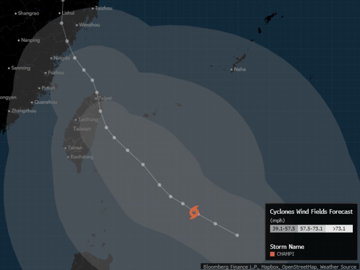
亚洲正为由厄尔尼诺现象助长的一连串强风暴中的最新一场做准备,台风“查帕卡”扰乱航班并威胁带来暴雨,正朝台湾逼近。
Asia is bracing for the latest in a string of powerful storms fueled by El Niño, with Typhoon Champi disrupting flights and threatening heavy rainfall as it tracks toward Taiwan.
根据美国联合台风警报中心的数据,“查帕卡”目前位于日本冲绳西南方向713公里(443英里)处,预计将于周五晚间至周六最接近台湾北部。虽然该风暴已从超强台风级别略有减弱,但仍携带最高持续风速每小时213公里,相当于四级飓风。
Champi is currently 713 kilometers (443 miles) southwest of Japan’s Okinawa and forecast to pass closest to northern Taiwan late Friday into Saturday, according to the US Joint Typhoon Warning Center. While the storm has weakened slightly from super typhoon strength, it’s still packing top sustained winds of 213 kilometers per hour, equivalent to a Category 4 hurricane.
香港天文台表示,这是今季西北太平洋第10个达到超强台风级别的风暴,数量是长期平均值的两倍,仅比2015年(同样是一个厄尔尼诺年)创下的13个纪录少3个。根据气象学家瑞安·莫维维护的数据库Climatlas的数据,以风速和中心气压衡量,“查帕卡”属于今年最强的风暴之一。
It’s the 10th storm in the northwest Pacific Ocean to hit super typhoon strength this season, double the long-term average and just shy of a record 13 in 2015 — also an El Niño year, the Hong Kong Observatory said. Champi is among the most powerful this year, based on wind speeds and central pressure, according to Climatlas, a database maintained by the meteorologist Ryan Maue.
“大气G2”北美和亚洲气象运营总监詹姆斯·卡伦表示:“厄尔尼诺是主要驱动因素。”在该气候现象期间,风暴倾向于在更偏东的位置形成,使气旋在向陆地移动的过程中有更多时间在开阔温暖的海面上积累能量。“正是这段时间让它得以达到超强台风级别,”卡伦补充道。
“El Niño is the main driver,” said James Caron, director of meteorological operations for North America and Asia at Atmospheric G2. Storms tend to form farther east during the climate phenomenon, giving a cyclone more time to accumulate energy over open and warm waters as it churns toward land. “That time is what lets it reach super typhoon strength,” Caron added.
台湾预计将承受“查帕卡”影响的主力,暴雨和破坏性大风威胁该岛。联合台风警报中心称,预计风暴在周末掠过中国大陆东部沿海时将维持台风强度,随后转向日本西南部的九州。
Taiwan is expected to take the brunt of Champi’s impact, with torrential rain and destructive winds threatening the island. The storm is forecast to maintain typhoon intensity as it brushes the eastern coast of mainland China over the weekend before heading toward Kyushu in southwest Japan, the JTWC said.
台湾当局预计将于今日稍晚决定是否停止台北市学校和办公机关上班上课,并可能暂停台湾证券交易所交易。根据台湾民用航空局的数据,截至周四上午,已有至少125个航班取消。
Taiwanese authorities are expected to make a decision later today on whether to close Taipei’s schools and offices, and potentially halt trading on the Taiwan stock exchange. At least 125 flights have already been canceled as of Thursday morning, according to Taiwan’s Civil Aviation Administration.
对于“潭美”的路径仍存在相当大的不确定性,基于人工智能的模型显示台风将在台湾近海经过,而许多基于物理的模型则显示台风将在台湾北部短暂登陆。Atmospheric G2的卡龙表示,这种情况大约在24小时内就会变得清晰。
There still remains considerable uncertainty over Champi’s track, with AI-based models keeping the typhoon offshore of Taiwan while many physics-based models show a brief landfall over the island’s north. That should become clear within about 24 hours, Atmospheric G2’s Caron said.
他说:“最大的威胁是台湾北部和东北部的极端降雨。”“10月下旬东北季风已经建立,经过附近的台风会将该气流拉向岛屿地形”,可能在大台北地区倾泻多达18英寸(457毫米)的雨量,并有引发灾难性山洪和滑坡的风险,卡龙补充道。
“The biggest threat is extreme rain over northern and northeastern Taiwan,” he said. “In late October the northeast monsoon is already in place, and a typhoon passing nearby pulls that flow into the island’s terrain,” potentially dumping as much as 18 inches (457 millimeters) over greater Taipei and risking catastrophic flash floods and landslides, Caron added.