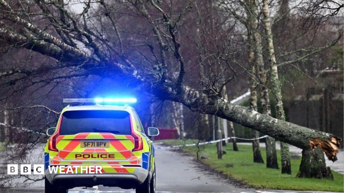
本季首个命名风暴“奥斯汀”周五给英格兰西南部带来大范围强风,旅行出行恐受干扰。
Disruption to travel is likely as the season's first named storm brings a swathe of powerful winds to south-west England on Friday.
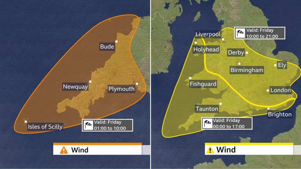
英国部分地区已生效橙色天气预警,风暴“奥斯汀”周五带来大范围强风和暴雨。
An amber weather warning has come into force in parts of the UK as Storm Austen brings a swathe of powerful winds and heavy rain on Friday.
英国气象局预警,英格兰西南部将受风暴冲击最重,可能造成交通中断、停电,并存在生命危险。
South West England is forecast to be worst hit by the storm which the Met Office warns could bring travel disruption, power cuts and a possible danger to life.
气象局预警生效至英国夏令时上午10:00,康沃尔郡和德文郡部分地区预计阵风达60-70英里/小时,暴露地带可达80英里/小时。
Wind gusts of 60-70mph, with 80mph in exposed locations, are forecast across Cornwall and parts of Devon, where the Met Office warning is in force until 10:00 BST.
英格兰和威尔士大部地区预计阵风达45-60英里/小时,两个级别较低的黄色预警将在周五全天生效。另一个单独的黄色预警将从英国夏令时上午06:00起覆盖苏格兰部分地区,包括格拉斯哥和爱丁堡。
Wind gust of 45-60mph are forecast more widely across most of England and Wales, where two less severe yellow warnings will be in force throughout Friday. A separate yellow warning will also cover part of Scotland, including Glasgow and Edinburgh, from 06:00 BST.
如此强度的风力将吹倒部分树木,带来显著的交通中断风险,也可能导致部分停电。
Winds of this strength will blow some trees over, bringing a significant risk of transport disruption and there may also be some power cuts.
如此强度的风力将吹倒部分树木,建筑物也可能受损,风暴最强时存在飞散碎片的风险。
Winds of this strength will blow some trees over while buildings could also potentially be damaged, leading to a risk of flying debris at the height of the storm.
受影响地区多所学校停课,许多其他学校推迟上课时间以避开最强风力。
A number of schools are closed in the impacted areas with many others opening later than usual to avoid the strongest winds.
因树枝和树木倒塌堵塞铁路的风险增加,火车可能取消或限速运行。多条渡轮航班也已取消,包括彭布罗克郡与爱尔兰之间的航线。
Train cancellations and speed restrictions are possible because of the increased danger of branches and trees blocking railways. A number of ferry sailings have also been cancelled, including crossings between Pembrokeshire and Ireland.
黄色大风预警覆盖英格兰和威尔士大部,预计周五阵风达45-60英里/小时,部分地区阵风可能达70英里/小时。
Yellow wind warnings cover most of England and Wales with gusts of wind on Friday forecast to reach 45-60mph, with 70mph gusts likely in some places.
尽管这些风力已很强劲,但破坏力最强的风力将出现在低压中心以南。
As strong as these winds are, the most damaging winds will run to the south of the low pressure centre.
这使得法国西北部正处于核心冲击区,布列塔尼部分地区阵风可能接近90英里/小时。海峡群岛也预计将遭遇烈风,阵风高达80英里/小时。
That puts north-west France firmly in the firing line and parts of Brittany could see gusts close to 90mph. The Channel Islands are also expecting severe gales with gusts up to 80mph.
由于预计“奥斯汀”风暴将带来强风,新泽西州的所有学校都被要求在周五关闭。
All schools in Jersey have been told to close on Friday because of the high winds predicted to be caused by Storm Austen.
苏格兰的强降雨可能导致局部地区发生洪水;英国气象局发布了黄色预警,预计降雨量将达到20至40毫米,部分地区在周五的降雨量可能累计达到80毫米。
Heavy rain in Scotland may cause some localised flooding with a Met Office yellow warning for 20-40mm of rain forecast with up to 80mm accumulating in a few areas through Friday.
在“奥斯汀”风暴来临之前,英国气象局已发布了风速预警;“博埃洛”风暴将于周末接踵而至。该风暴由英国气象局于周四命名,预计将在周末给英国带来新一轮暴风雨天气。
Wind warnings have been issued ahead of Storm Austen's arrival on Friday Storm Boelo to bring travel disruption over the weekend Closely following Storm Austen will be Storm Boelo, named by the Met Office on Thursday and set to bring another round of stormy weather to the UK over the weekend. Boelo will bring wet and windy weather across the whole of the UK on Saturday with poor travelling conditions expected due to surface water and spray on faster roads and motorways.
“博埃洛”风暴将在周六给整个英国带来潮湿且多风的天气,由于道路和高速公路上的积水及飞溅物,交通状况预计会非常糟糕。
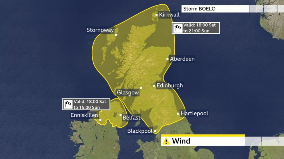
The Met Office has issued yellow wind warnings for Scotland, Northern Ireland and northern England, valid on Saturday and lasting most of Sunday.
英国气象局已对苏格兰、北爱尔兰和英格兰北部发布了黄色风速预警,这些预警在周六生效,并将持续到周日的大部分时间。
Gusts are forecast to reach 50-65mph widely and could reach 80mph in exposed locations.
预计风速将达到每小时50至65英里,在开阔地带甚至可能达到每小时80英里。强风可能会在某些地区造成局部交通中断和停电。由于近期持续降雨,局部地区发生洪水的风险也有所增加。在“博埃洛”风暴来临之前,英国气象局再次发布了风速预警。
There could be some localised disruption with strong winds funnelling through the Central Lowlands for a time. Transport disruption is expected and there may be some power cuts. Following recent spells of wet weather, there is an additional risk of some localised flooding. Yellow wind warnings have been issued ahead of Storm Boelo's arrival over the weekend Is it unusual to see two storms so close together?
连续出现两场风暴的情况并不罕见——事实上,这样的风暴常常会成群出现。
It is not unusual to get storms one after another - in fact they quite often arrive in clusters.
强风暴的形成需要强大的急流作用;其形成过程涉及将较暖的空气向北输送、较冷的空气向南输送,这一过程会覆盖大西洋的广阔区域。
A strong jet stream is needed to rapidly develop powerful wind storms.
这些温差可以为新的低压系统发展提供有利环境,如果这些系统随后被引导至强劲急流的发展区域之下,它们可能会迅速增强,形成一场带有破坏性大风的新命名风暴。我们何时会看到最多的命名风暴?
The process involved in creating such storms involves shifting warmer air northwards and cooler air southwards across vast areas of the Atlantic. These temperature contrasts can provide a fertile environment for new low pressure systems to develop and if these subsequently get steered beneath a developmental area of a powerful jet stream, they can rapidly develop to create a new named storm with damaging winds.
12月、1月和2月这三个冬季月份通常会产生最多的英国风暴。虽然命名风暴一年四季都可能影响英国,但分析显示,它们在春季和初夏要少见得多。
When do we see the most named storms? The winter months of December, January and February typically produce the highest number of UK storms Although named storms can affect the UK at any time of the year, analysis shows they are much less common in spring and early summer.
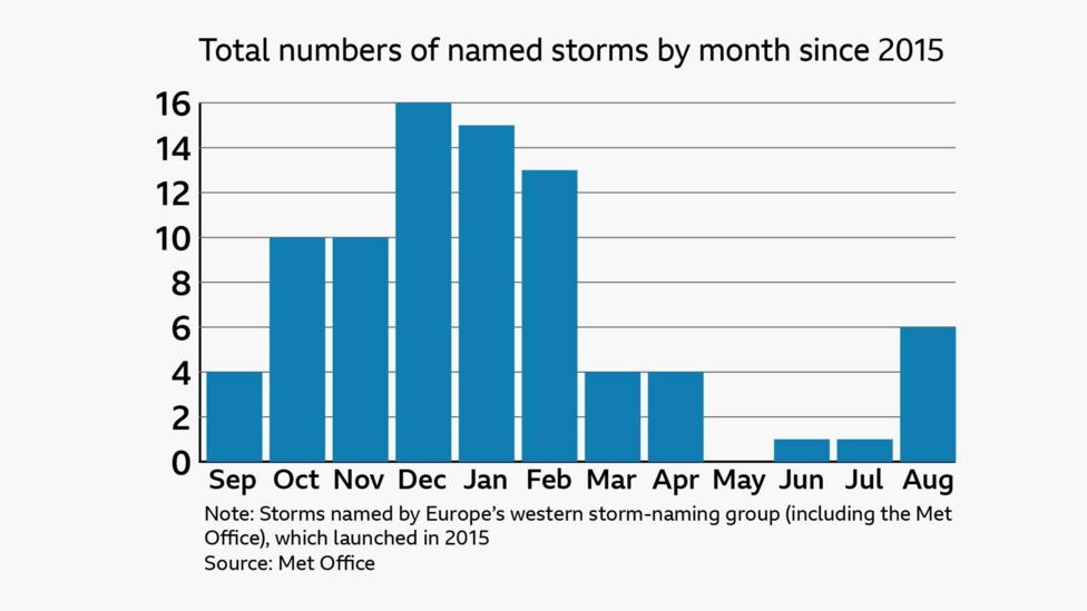
5月是过去11年英国命名风暴制度实施以来,唯一一个没有出现命名风暴的月份。
May is the only month with no named storms in the 11 years that storms have been named in the UK.
从晚夏到整个秋季,遭遇风暴的几率逐渐增加,风暴季的高峰期出现在冬季月份。
The chances of seeing a storm increases from late summer and throughout autumn with the peak of the season arriving in our winter months.
风暴活动的这种增加,就是为什么每年的风暴命名季从9月开始的原因。
This increase in storminess is why the storm-naming season begins in September each year.
自2015年以来,大约有一半年份的首个风暴是在11月1日之后到来的。
In about half of the years since 2015, the first storm arrived after 1 November.
英国气象局发布2026-2027年新风暴名称 超级厄尔尼诺现象增强至“前所未有的水平”再创纪录 多风的秋天、寒冷的冬天——厄尔尼诺现象可能如何影响英国天气?
New storm names for 2026-2027 released by Met Office Super El Niño sets another record as it strengthens to 'unprecedented levels' Stormy autumn, cold winter - how might El Niño affect the UK weather?