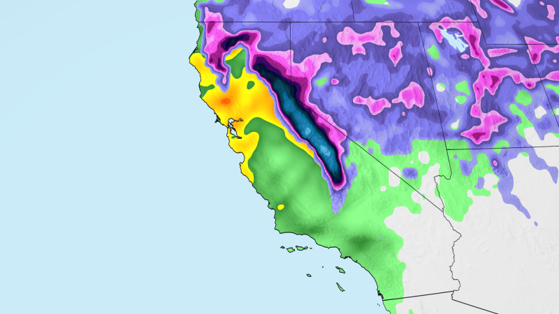
本周,加利福尼亚州大部分地区将面临暴雨、高山大雪和阵风威胁,因为一场即将来袭的风暴将带来本季最广泛的大气河流。
Flooding rain, heavy mountain snow and gusty winds will threaten most of California this week as an incoming storm pulls in the most widespread atmospheric river of the season.
在CNN天气应用中追踪风暴 大气河流是大气中一条狭长的区域,能将水汽输送数千英里,如同天空中的消防水带。随着潜在的历史性超级厄尔尼诺现象提高加州湿润冬季的可能性,未来几周和几个月,加州可能还会迎来更多由大气河流驱动的风暴。
Track the storm in the CNN Weather app An atmospheric river is a long, narrow region in the atmosphere that can transport moisture thousands of miles, like a fire hose in the sky. California is likely to see plenty more atmospheric river-fueled storms in the weeks and months to come as a potentially historic super El Niño boosts the state’s odds of a wet winter.
这场风暴将在周三之前席卷加州,并持续到周四,洪涝暴雨威胁将从旧金山湾区延伸至洛杉矶和圣地亚哥。洛杉矶国家气象局称,即将到来的系统是“本季第一场真正带来广泛中到大雨和高海拔山区降雪的风暴”。北加州和太平洋西北地区在周末至周一期间已遭遇一系列风暴袭击。巨大海浪拍打太平洋沿岸大部分地区,损毁了蒙特雷湾历史悠久的卡皮托拉码头;湾区高速公路被深达2英尺的洪水淹没;索诺马县阵风时速高达64英里。本周预计情况如下:周三清晨起,暴雨将降临旧金山湾区和中海岸地区。
The storm will spread across California by Wednesday and linger through Thursday, with the threat of flooding rainfall stretching from the Bay Area down to Los Angeles and San Diego. The National Weather Service in Los Angeles calls the coming system “the first storm of the season with truly widespread moderate to heavy rain and high elevation mountain snow.”Northern California and the Pacific Northwest have already been battered by a series of storms over the weekend into Monday. Massive waves pounded much of the Pacific Coast, damaging Monterey Bay’s historic Capitola Wharf, while floodwater as deep as 2 feet inundated Bay Area highways, and wind gusts up to 64 mph buffeted Sonoma County. Here’s what to expect this week. Heavy downpours will arrive across the Bay Area and Central Coast beginning early Wednesday morning.
据天气预报中心称,这些地区周三面临2级(共4级)洪涝暴雨风险。该地区大部分地区预计降雨量为1至2英寸,局部地区,尤其是沿海山区,可能降下3至4英寸。
These areas are under a Level 2 of 4 risk for flooding rain Wednesday, according to the Weather Prediction Center. Rainfall totals of 1 to 2 inches are forecast across much of the region, with 3 to 4 inches possible in spots, especially in the coastal mountain ranges.
随着风暴锋面移动,大部分最强降雨可能在三到六小时内落下。在更强降雨过后,阵雨将持续到周四。强降雨与连续风暴导致地面日益饱和相结合,可能引发道路洪涝。
Much of the heaviest rain could fall in just three to six hours as the storm’s front moves through. Periods of showers will persist in the wake of that heavier burst through Thursday. The combination of intense downpours and increasingly saturated ground from the back-to-back storms could lead to flooding on roads.
向内陆深处,萨克拉门托河谷及附近的内华达山脉山麓地区周三和周四可能至少降下 1 英寸雨量,部分地区可能达到 2 英寸或更多。
Farther inland, at least 1 inch of rain is likely across the Sacramento Valley and nearby Sierra Nevada foothills, with 2 inches or more possible in some areas Wednesday and Thursday.
洪水威胁将于周三深夜至周四清晨蔓延至洛杉矶、圣地亚哥及周边山区。据天气预测中心称,南加州部分地区(包括上述大都会区)周四面临 4 级中的 2 级洪水风险。
The flooding rain threat will spread to Los Angeles, San Diego and surrounding mountain areas by late Wednesday night into Thursday morning. Parts of Southern California, including those metros, are under a Level 2 of 4 risk of flooding rain Thursday, according to the Weather Prediction Center.
南加州部分地区可能降下 1 至 3 英寸雨量,部分山坡局地可能达到 3 至 5 英寸。
Rainfall totals of 1 to 3 inches are possible across portions of Southern California with locally higher amounts of 3 to 5 inches possible on some mountain slopes.
洛杉矶国家气象局表示,最强降雨将集中在周三深夜至周四清晨的 4 至 8 小时窗口期内。
The biggest punch of heavy rain will be within a four-to-eight-hour window from late Wednesday night through Thursday morning, the National Weather Service in Los Angeles said.
城市地区可能发生洪水,峡谷道路可能遭遇落石滑坡。近期烧毁区域也易引发洪水和碎屑流,尤其是雷暴带来短时强降雨时。烧毁地面吸水能力下降,强降雨还会松动土壤,使雨水更易将其冲刷向下游。
Flooding is possible in urban areas and rockslides could tumble down on canyon roads. Recently burned areas could also be prone to flooding and debris flows, especially if thunderstorms bring short bursts of heavier rain. Burned ground can’t absorb as much water and intense rainfall rates can also loosen up soil, making it easier for rain to carry it downhill.
冷空气随风暴而来,内华达山脉因大雪发布了冬季风暴观察预警和警报,这虽利好滑雪场,但将造成严重交通困扰。
Cold air is also accompanying this storm, and winter storm watches and warnings are posted for heavy snow in the Sierra Nevada, which, while beneficial for ski resorts, will cause major travel headaches.
唐纳山口的 80 号州际公路等山口自周三起将出现危险路况,降雪率达每小时 1 至 2 英寸,并伴有大风。
Mountain passes like Interstate 80 through Donner Pass will see dangerous travel conditions beginning Wednesday with snow falling at rates of 1 to 2 inches per hour alongside gusty winds.
积雪海拔可低至 4000 英尺,海拔 5000 英尺以上山区至周四夜间积雪至少 2 英尺,局地可能达 3 英尺或更多。
Snow could accumulate at elevations as low as 4,000 feet, with at least 2 feet likely in some mountain locations above 5,000 feet through Thursday night. A few areas could receive 3 feet or more.
强风也将伴随风暴而来,周三和周四,旧金山湾区部分地区以及北加州内陆其他地方可能出现每小时30至45英里的阵风。这可能足以吹倒一些树木,并导致零星停电。
Strong winds will also accompany the storm, with gusts of 30 to 45 mph possible in parts of the Bay Area and elsewhere in interior Northern California on Wednesday and Thursday. That could be strong enough to down a few trees and cause scattered power outages.